


i-Boating:Canada & USA Marine Apk by Gps Nautical Charts
Gallery:


About i-Boating:Canada & USA Marine
This App offers access to CHS marine vector & raster charts. First marine GPS app to have route assistance with Voice Prompts for marine navigation. You can create new boating routes or import existing GPX/KML routes. It supports Nautical Charts course up orientation. Includes Tide & Currents prediction.
(Includes coverage for Trent Severn Waterway incl. lake Simcoe etc.)
►FEATURES
√ Beautiful and detailed Hardware/GPU accelerated vector charts (text stays upright on rotation)
√ Long press to query the details of Marine object (Buoy, Lights, Obstruction etc).
√ Customizable depth(Ft/Fathom/Meter) and distance units (km/mi/NM)
√ Customizable Shallow Depth.
√ Record tracks, Autofollow with real-time track overlay & predicted path vector.
√ Voice Prompts for marine navigation (requires GPS )
√ 1ft / 3ft depth contour maps for anglers for selected lake maps.
√ Supports GPX/KML for boating route editing/import.
√ Tide & Currents prediction.
√ Seamless chart quilting of marine charts
√ Enter or import Waypoints.
► Advanced NMEA Instrumentation
√AIS over TCP/UDP
√Wind speed, direction, temperature, depth, GPS over NMEA
► MAPS
The maps include coverage of Pacific Coast, Central Canada(incl. Great Lakes, Trent Severn Waterway, Ontario Lakes), Atlantic coast derived from CHS data.
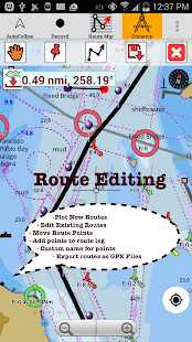
►ROUTE MANAGEMENT / TRIP PLANNING
√ Create New Route/Edit Existing Routes
√ Move Points
√ Add points to an existing route leg
√ Delete / Rename points
√ Import GPX, KML & KMZ files
√ Plot/Edit Routes
√ Enter Waypoints
√ Share/Export Routes, Tracks & Markers
√ Reverse Routes
►GPS FEATURES
√ Auto Follow
* Real Time Track Overlay
* Predicted Path Vector
* Course Up (Text stays upright)
* Speed & Heading
√ Route Assistance With Voice Prompts
* Prompts when approaching a boating route marker
* Continous distance and ETA updates
* Alerts when sailing/boating off route
* Alerts when boating in wrong direction
√ Record Tracks
►Custom Base Map
√ Satellite/Aerial Imagery, Street Maps etc.
►TIDE & CURRENTS
* For US, Canada, UK, Germany & New Zealand
* High/Low Tides
* Tidal Current Prediction
* Active Current Stations
► SHARING
* Share tracks/routes/markers on Facebook & Twitter
* Export tracks/routes/markers as compressed GPX files.
►Avaliable Chart Folios
√ Rainy Lake and Lake of the Woods
√ Quebec to Anticosti Island West
√ Gulf of St. Lawrence South
√ Ontario Lakes : Lac Seul &des Mille Lacs
√ Trent-Severn Waterway
√ Labrador Coast
√ Lac Saint Jean
√ Rideau Canal – Ottawa River
√ Georgian Bay
√ Newfoundland East and South
√ Great lakes Canada and St. Lawrence river
√ Lakes and Rivers in Manitoba and Saskatchewan
√ Lakes and Rivers of British Columbia
√ Pacific Coast – Vancouver Island East & West – Haida Gwaii
√ Lakes around Georgian Bay
√ Gulf of St. Lawrence North – Newfoundland West
√ Alberta Lakes
√ Nova Scotia South – Bay of Fundy
►Online Chart Viewer
http://fishing-app.gpsnauticalcharts.com/i-boating-fishing-web-app/fishing-marine-charts-navigation.html#11.1/49.3520/-123.1202
i-Boating:Canada & USA Marine APK details:
- App Name: i-Boating:Canada & USA Marine
- Current Version: 86.0
- Price: Check in PlayStore
- Updated: June 19, 2016
- Content Rating: Everyone
- Android Version: 4.0 and up
- Mirror: Openload
- Developer: Gps Nautical Charts
Changelog:
- ►Custom Base Map
- √ Satellite/Aerial Imagery, Street Maps etc.
- ** Advanced NMEA Instrumentation
- -AIS over TCP/UDP
- -Wind speed, direction, temperature, depth, GPS over NMEA
Download i-Boating:Canada & USA Marine apk the latest version:


Enjoy using i-Boating:Canada & USA Marine on your Android! If you find any bugs, mistakes or outdated links, simply contact us. We will fix it immediately.
Comments
So empty here ... leave a comment!